
Mesopotamia means the “land between the rivers”. The Tigris and Euphrates Rivers have their source in the mountains to the north in Syria and Iran and grow ever closer as they make their way through this ancient land. They eventually meet, and their waters become the Shat El Arab which empties into the Persian Gulf. Today the area formerly known as Mesopotamia is, for the most part, within Iraq.

This is the land of the first civilizations: the Sumerians, the Akkadians, the Elamites, Amorites, Kassites, the Assyrians. Sumerian empires lasted for thousands of years on and between the rivers. In his classic historical outline, H.G. Wells notes that the great cities of Mesopotamia such as Babylon, Ur, Uruk and Nineveh, “have already an immemorial past when first they appear in recorded history.” (Wells, 1920) In the passage of all that time, these remarkable people invented cultivation, irrigation, the city itself, written language, the wheel and gave us the first example of codified law: The Code of Hammurabi (Hammurabi was king of the first Babylonian Empire). The Code’s purpose as stated in its preamble was,
“to bring about the rule of righteousness in the land, to destroy the wicked and the evil-doers; so that the strong should not harm the weak.” (King, 2015)
When Sumerian empires gave way to invasions by the Akkadians no dark age followed. These conquerors could not fail to recognize the achievements of the Sumerians, and they continued this civilizing trajectory by adopting Sumerian writing, law and technologies and by making their own contributions. The Amorites seized power from the Akkadians and after them the Elamites and then the Kassites.
“For four thousand years this new thing, civilization, which had set its roots into the soil of the two rivers grew as a tree grows….It changed its dominant race; it changed its dominant language, but it remained essentially the same development. After four thousand years the warriors and conquerors were still going to and fro over this growing thing” (Wells, 1920).
Mesopotamia was the very centre of the civilizing world. But this ascendancy was gradually lost as the once highly productive, and continuously irrigated farmland began to draw salty groundwater to the surface soils and food production started to decline. By 2000 BC what was once fertile alluvial plain had become salt pans and this source of human civilization went into a steady decline. The desert that surrounds ancient sites of the Sumerian empire at Ur and Uruk are testimony to this man-made ecological disaster. Even today, nearly half of the irrigated land in Iraq is saline (Wright, 2004).
While Mesopotamia’s prominence slipped away, the passage of conquerors and ideas continued. By 750 A.D., Mesopotamia was part of the Islāmic Empire which spread from Mecca in Arabia and at its peak stretched from the Indus River in the east to the coasts of Spain. By the time of the First World War, the Ottoman Turks had reigned over the land for nearly 400 years.
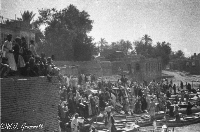
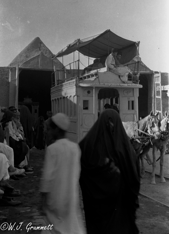
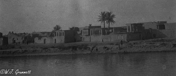
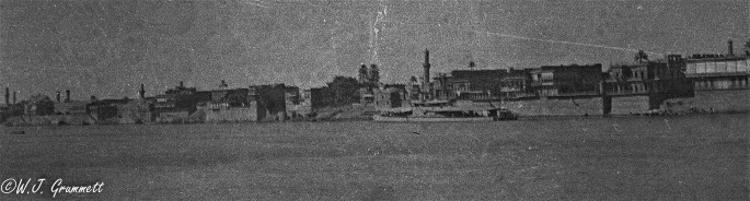
None of the grandeur of this land or its history was lost on Will Grummett. He did beat the malaria that had put him in hospital at Belgaum, and he made it to Mesopotamia and the war, and he brought his camera. How all that happened, where he went and how he got there, is the subject of next month’s post, Post# 8 To the Persian Front. For now, once he got there, he took some wonderful photographs of the country and its magnificent capital, Baghdad.
Enjoy the music of the Faran Ensemble while you read on or look at pictures. Their music is described as “a magic carpet to take the listener on a voyage to faraway lands.”


But, of course, the interest of the world’s competing powers at the time of the First World War was not, ancient empires and people or even arable land but strategic geography, and, then as now – oil.
Historians seem to agree that the British Mesopotamian campaign began in part (and in concert with its efforts in Palestine) as an effort to protect the vital shipping route through the Suez Canal. Prior to the outbreak of the war, the Ottoman Empire and Germany, recognizing mutual interests in the game of empires, began working together on a rail line from Berlin to Baghdad. Not surprisingly, the British saw this as an effort to make Mesopotamia defensible by the Turks and their allies, the Germans. A firm foothold anywhere within striking distance of the Suez Canal was, it seems, out of the question for the British.
By as early as 1910, oil was flowing down pipelines to a British owned and operated storage and refining facility at Abadan on the Shaat El Arab south and east of Basra. The Anglo-Persian Oil Company held significant rights to oil deposits in Mesopotamia and in Persia and had established its base of operations at Abadan (Mcmeekin, 2015).

Historian Peter Hart argues that, “ The origins of the Mesopotamian campaign lay at sea with the adoption by the Royal Navy of oil-fired turbines for the new generation of warships…” (Hart, 2013). Whether fueling British warships or some other purpose, protecting the supply of oil was no veiled objective of the campaign. In his official summary of the action in Mesopotamia, Lieutenant Colonel R. Evans states quite plainly that “Its purpose was to protect one minor point of strategic importance, the Anglo Persian oil fields” (Evans, 1930). The insatiable demand for oil had begun and therefore securing the oil fields had become a strategic priority.
Following the disaster that was the siege at Kut-Al-Amarah (see Post #5), the British retreated and regrouped but had maintained a hold on important ground including the port at Basrah and Abadan and the lower reaches of the twin rivers. It was from here that the Mesopotamian Expeditionary Force (MEF) with General Fredrick Stanley Maude commanding, began the effort to secure the oil supply and the strategic geography of Mesopotamia for the British Empire. What had begun with the methodical preparation of men and means of supply (see Post #6) continued in the same methodical, way. In a succession of battles culminating with the battle for Baghdad, General Maude engaged and then pursued the Turkish army under the command of Ishmael Hakki Bey or as he is more commonly referred to, Khalil Pasha, back up the Tigris River toward Baghdad.
The action opened with immediate successes at the battles of the Hai Salient and Dhara Bend, and by late February of 1917 Maude’s MEF was poised to retake Kut-Al-Amara (Evans, 1930).
( view the 1:32 scale map from Will Grummett’s map case to get a sense of where the fighting was taking place. Note, not all place names of battles are included. Click here: Basrah to Baghdad ).
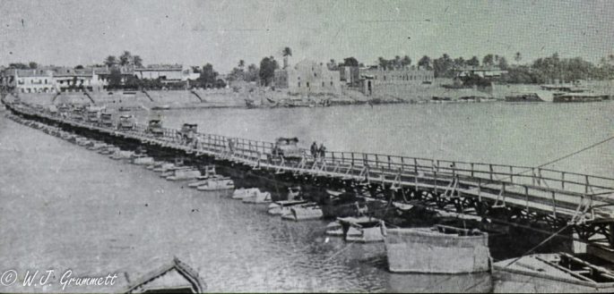
At Kut, Khalil Pasha had concentrated his force, constructing formidable defenses (Rogan, 2015). The Battle for Kut began on February 22 of 1917. Artillery bombardment of the entrenched Turkish forces was quickly followed by infantry attacks. The MEF attacked the enemy head on in a frontal assault, and suffered heavy losses before elements of the 14th Indian Division breached the Tigris River and crossed to the opposite bank at Shumran Bend (Daugherty, 2003). Here the MEF installed a pontoon bridge and, quickly funneling cavalry and infantry across the river, they surprised the Turks, forcing them to retreat from Kut or risk encirclement and capture (Rogan, 2015).
The Turks fell back on Baghdad, fighting a rear guard action much of the way. The third battle for Kut was over and the 4 Turk divisions in defence paid a heavy cost in lives reducing their numbers to some 5000 men (Evans, 1930). Casualties on the British side were very high, but General Maude was able to maintain his strength in the field, drawing on the newly committed troops he held in reserve.

By March 6 (1917), Maude and his army were at the outskirts of Baghdad. Having been given the green light to take Baghdad, the MEF engaged the Turks along the Diyala River south and a little to the east of the city. Here Khalil Pasha ordered his Army to stand and hastily began to dig a network of trenches along an eight mile front (Mcmeekin, 2015).

For three days they fought with heavy losses on both sides. At the end of those bloody three days, 100 men from the East Lancashires of the 38th Brigade forded the Diyala under heavy fire establishing a defendable crossing. At the same time cavalry units had outflanked the Turkish defensive line and were busy taking the main railway terminus at Baghdad (Evans, 1930). The Turkish commander concluded that he could no longer defend Baghdad against Maude’s army. What was left of the Turkish army retreated west north-west to Al-Falujah and Ramadi on the Euphrates River (Rogan, 2015).
On March 11th when the British marched into Baghdad, Will Grummett and his comrades were deep into the curriculum at The School of Instruction for Young Officers at Ambala in northern India (see Post#6). I am sure the discussion among his fellow officers included thoughts that the capture of Baghdad meant the war in this part of the world was, for all intents, over. The truth is that there is a lot of Mesopotamia north of Baghdad, and the Turks, regardless of the defeats and damage to their army, were not about to give it up and walk away without a long and bitter fight. The Turkish army remained in northern Mesopotamia and remained a threat up to the armistice in November of 1918.
As one of his first acts upon entering Baghdad, General Maude released a proclamation that included the statement, “our armies do not come into your cities and lands as conquerors or enemies, but as liberators“. Without sounding too cynical, one could add – so long as the Suez remained secure for British shipping and the flow of oil into British tankers, uninterrupted. What the world saw was that Britain had triumphed, restoring its credibility as a power in the region, thwarting the plans for the Berlin to Baghdad Railway and any possibility of a Turkish-German dominance in Mesopotamia.

Concerned that his supply lines were growing too long, General Maude slowed the advance and consolidated his gains.(Evans, 1930) He also knew that the coming hot weather could both injure and kill and no significant military objectives would be attempted at least until October and cooler weather.
The British took up positions as far north as Samarra on the Tigris River (Tigris Front) and to the west of Baghdad as far up the Euphrates as Khan Baghdadi (Euphrates front) forcing the Turks to abandon both Al -Falujah and Ramadi. To the east, the British faced the Turks, who were holding the hills known as the Jebel Hamrin (London Gazette, Sixth Supplement, 26th August, 1918) along a line from Shaharaban north and east along the Diyala river and the “Tehran Road” to the Persian border: this was the Persian Front.

Next installment coming in July, To the Persian Front
